MAIN SECTIONS >  Home  Gloucester Docks  Sharpness Docks  G&S Canal  Vessels  People  Studies
G&S CANAL PAGES >  Canal Intro  Sharpness to Saul  Saul Junction  Saul to Gloucester  Access Map
 

Gloucester Docks &
the Sharpness Canal


Sharpness to Saul Junction


This page describes the main features of the southern half of the canal, and the following links lead to pages providing more detailed information:

Purton Barge Graveyard  Patch Bridge Replacement
 

General
     Most of the southern half of the canal is embanked so that the water level is above the general level of the surrounding land. These banks have periodically caused concern to successive engineers, but a fortunate consequence is that boaters on the canal or walkers along the towpath can enjoy extensive views. Access points where car parking is available are noted below.

Severn Railway Bridge
     The bridge was built in the 1870s to allow coal from the Forest of Dean to be brought across the river to Sharpness to provide an export cargo and fuel for steamers. It had 21 spans supported on piers across the river and a swinging section across the canal that opened to allow vessels to pass.

Severn Railway Bridge

Remains of the Severn Railway Bridge

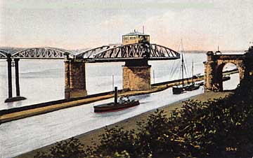
A vessel requiring the swing section to open sounded three blasts on its whistle, but if a train was due the vessel would have to wait until the train passed over. (PC W Merrett)

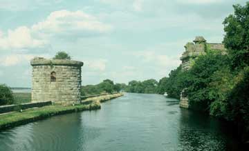
After two tankers collided with one of the piers in the river and brought down two spans in 1960, most of the bridge was demolished, leaving this masonry on either side of the canal.

Purton Barge Graveyard
     The narrow bank between the canal towpath and the River Severn to the north of the Severn Railway Bridge has long been used as a graveyard for old barges, with the aim of protecting the bank from erosion by the strong currents in the river (more details).

Purton Lower Bridge
     This originally carried the former turnpike road from the Bristol road through Breadstone and Halmore to Purton ferry. The ferry linked with another Purton on the west bank of the river until it was superceded by the Severn Railway Bridge in 1879. The road now leads to a few houses and to the Berkeley Arms.

Purton Upper Bridge
     This carries a minor road from Purton to fields belonging to the Berkeley family, who insisted the bridge was provided even though it was so close to the Lower Bridge. Beside the bridge is a classical-style bridgeman's house. The hamlet of Purton developed during the nineteenth century, providing homes for canal workers and Severn pilots.

Patch Bridge
     This carries a minor road from Slimbridge and Shepherds Patch to the New Grounds and the Slimbridge Wildfowl and Wetlands Trust Centre. Shepherds Patch developed during the nineteenth century, providing homes for canal workers. Near the bridge are the Black Shed Café Bar and Glevum Boat & Cycle Hire on Patch Wharf and the Tudor Arms a few yards away.

Patch Bridge and shed 

Patch Bridge and shed 

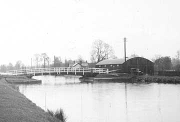
The black shed beside Patch Bridge was built in 1911 to store grain on its way to Draycott Mills, Cam. (PC M.Boakes)

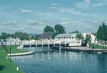
The shed is now occupied by the Black Shed Café Bar and Glevum Boat & Cycle Hire. Patch Bridge Replacement

Cambridge Arms Bridge
     This carries Ryalls Lane from Cambridge on the A38 to the New Grounds. Nearby is a classical-style bridgeman's house. The bridge name does not refer to a public house and perhaps should have an apostrophe to mean the bridge associated with the nearby Cambridge Arm. The Cambridge Arm was formed as a navigable feeder, bringing the water of the River Cam into the main canal and having a wharf near the Bristol road serving Cam and Dursley.

Splatt Bridge
     This carries a minor road leading to fields. Nearby is a classical-style bridgeman's house. The name is derived from the ancient plot of waste ground around the head of Frampton Pill, an inlet from the River Severn once used by small vessels supplying the village of Frampton-on-Severn.

Fretherne Bridge
     This carries what was a turnpike road through Frampton-on-Severn to Fretherne and the ferry between Arlingham and Newnham. Nearby is a classical-style bridgeman's house. On the opposite side of the canal is Frampton Wharf, now a small car park, and beyond that is the former Cadbury's factory.

Tow passing Cadbury's factory

Boat passing Cadburys factory 

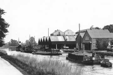
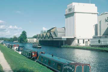
Cadbury's factory near Fretherne Bridge was established in 1916. Ground cocoa beans and sugar were blended with milk collected from local farms, and the mixture was baked to form chocolate crumb. This was taken by boat to Bournville for final processing. (Photo Cadbury's)

As throughput increased, the huge concrete silo was needed to provide additional storage for the crumb. The factory closed in 1983, and the site is now shared by a number of businesses, including Shipton Mill and AP Fuels.

Sandfield Bridge
     This carries a minor road from Whitminster to Saul and takes its name from the nearby field. On one side of the bridge is a Second World War strategic food store later used as a commercial wharf. On the other side of the bridge are the former stables for towing horses that were converted to The Stables Cafe in 2008.

 Return to Top Menu   Copyright 2003-08 Hugh Conway-Jones  Contact