MAIN SECTIONS >  Home  Gloucester Docks  Sharpness Docks  G&S Canal  Vessels  People  Studies
G&S CANAL PAGES >  Canal Intro  Sharpness to Saul  Saul Junction  Saul to Gloucester  Access Map
   

Gloucester Docks &
the Sharpness Canal


Saul Junction to Gloucester


This page describes the main features of the northern half of the canal, and the following links lead to pages providing more detailed information:

Two Mile Cut   Netheridge Bridge   High Orchard Bridge
 

General
     Much of the first part of the canal north from Saul Junction is embanked, but this is not always apparent because mud dredged from the canal has been dumped on some fields, raising their level by several feet. Further north, the canal passes through higher ground, which required a major effort on the part of the navvies who dug the original trench with just picks and shovels.

Pegthorne Bridge
     This formerly stood near where the grid lines now cross the canal. Some called it Packthorne Bridge after the nearby farm, but Pegthorne was the name used in the Canal Co. records. It linked two parts of a farmer's land until it was damaged during the Second World War and never replaced. On the south-east side of the canal is the ruins of a small brick building, originally provided as a shelter for the bridgeman.

Parkend Bridge
     This carries a minor road from the A38 at Parkend to Epney and Longney. Nearby is a classical-style bridgeman's house. The bridge is often called Castle Bridge after the Castle Inn which once stood beside the canal, the name later being adopted by the restaurant along the canal bank.

Hardwicke Bridge

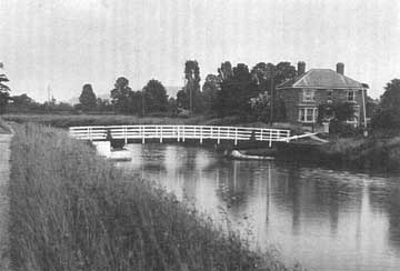
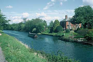
Hardwicke Bridge carried a private road linking two parts of the estate based on nearby Hardwicke Court. The house on the right was built by a former coal merchant who had a yard off the picture to the right. (PC M.Boakes)

After protracted negotiations with the Hardwicke estate, the bridge was abandoned in 1985, and subsequently removed, to save the cost of a bridgeman. The classical-style bridgeman's house has been restored after a period of dereliction.

Sellars Bridge
     This carries a minor road from the Old Bristol Road (A4008) to Elmore, Stonebench and Longney. Nearby is a classical-style bridgeman's house. The name comes from the nearby Sellars Farm, which has been almost overwhelmed by housing, and the alternative name of Pilot Bridge comes from the Pilot Inn which overlooks the bridge.

Quedgeley Oil Depot


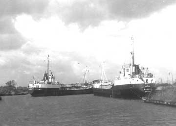
In 1960, Shell Mex & BP opened a depot to the north of Sellars Bridge with storage tanks for a wide range of petroleum products. Deliveries were initially by tanker barges and later by the coastal tankers shown above. (Photo: K Gibbs)

The depot closed in 1985, and only the quay used by the tankers remains. The storage tanks have been replaced by a housing estate, in which the former role is commemorated by the roads being named after some of the regular barges.

Rea Bridge
     This carries a minor road from the Old Bristol Road (A4008) to Stonebench and Elmore. Nearby is a classical-style bridgeman's house. The surrounding land is higher than the canal, and smaller boats can pass under the bridge without the need for it to be opened.

Sims Bridge
     This carries Sims Lane from the Old Bristol Road (A4008) to private land. It is another high level bridge which smaller boats can pass under. The name comes from the former Sims Farm that once stood beside the approach road.

Netheridge Bridge
     This bridge carries Gloucester's South West Bypass, completed in May 2007 following the construction of Two Mile Cut which bypasses the former Two Mile Bend. The bridge takes its name from the former farm nearby. Further pages give information about the construction of
Two Mile Cut and Netheridge Bridge.

Gloucester Rowing Club

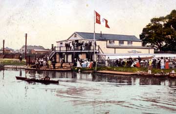
Gloucester Rowing Club built this clubhouse below Hempsted Bridge c1900, having previously used premises nearer Gloucester. (PC M.Boakes)

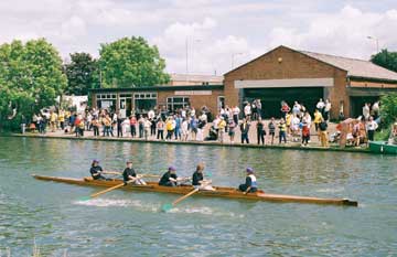
The old wooden building was replaced in 1963. The club's major annual event is an open regatta held each August Bank Holiday Saturday.

Hempsted Bridge
     This used to carry a minor road from the Bristol Road to Hempsted, but vehicular traffic was stopped after the opening of Netheridge Bridge. The long low building beside the bridge was once used for storing salt, brought by boat from Worcestershire, to be taken away by visiting ships as an export cargo. From here to Gloucester, most of the east bank of the canal and part of the west bank were once lined by timber yards. Three timber companies still have yards beside the canal, but all wood is now brought in by road.

High Orchard Bridge
     This fine bridge, completed in 2008, carries St Ann Way across the canal, taking traffic around the south of Gloucester and aiding access to the Gloucester Quays regeneration scheme. The bridge takes its name from the old name of the adjoining land. (More information about
High Orchard Bridge and High Orchard)

Return to Top Menu   Copyright 2003-08 Hugh Conway-Jones   Contact