1. Llanthony Bridge, Gloucester
There is a pay-and-display
car park in Southgate St overlooking the Victoria Dock. (Satellite map)
1a. High Orchard Bridge, Gloucester
There
is a car park in the Gloucester Quays designer outlet centre on the east side of the bridge. (Satellite
map)
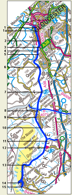 2. Hempsted Bridge 2. Hempsted Bridge
There
is no provision for parking near the bridge, but it is usually possible
to find a space on the west side now that the bridge is no
longer open to vehicles. (Satellite map)
3. Netheridge Bridge, Quedgeley
While
there is no provision for parking close to the bridge, it is possible
to find spaces in the nearby side roads. (Satellite map)
4. Sims Bridge, Quedgeley
There
is a very small unofficial car park on the east side of the bridge.
(Satellite map)
5. Rea Bridge, Quedgeley
There
is a car park on the east side of the bridge. (Satellite
map)
6. Sellars Bridge, Hardwicke
There
is limited unofficial parking on either side of the bridge. (Satellite
map)
7. Parkend Bridge, Moreton Valence
There
is limited unofficial parking alongside the road on the west side
of the bridge. (Satellite map)
8. Sandfield Bridge for Saul Junction
From
the west side of this bridge, there is access to the excellent pay-and-display
car park beyond the public toilets and close to Saul Junction. Before
the toilets, there is time-limited parking for those visiting
the Stables Cafe. (Satellite
map)
The postcode is GL2 7LA.
9. Fretherne Bridge, Frampton
There
is a small public car park on the east side of the bridge.
(Satellite map)
10. Splatt Bridge, Frampton
There
is a small public car park on the east side of the bridge. (Satellite
map)
11. Cambridge Arms Bridge
There
is very limited unofficial parking on the east side of the bridge.
(Satellite map)
12. Patch Bridge, Slimbridge
There
is parking for customers of the Slimbridge Boat Station and the
Tudor Arms, but otherwise there are only a few unofficial spaces
on the east side of the bridge. (Satellite map)
13. Purton Upper and Lower Bridges
There
is an excellent public car park to the south of
Purton Upper Bridge and limited unofficial parking on the north
side of Purton Lower Bridge. (Satellite map)
14. Sharpness Old Dock
The
dock estate is private property, but there is usually pedestrian
access to the Old Dock and the towpath from the square flat area used for
unofficial parking to the west of the Low Level Bridge, reached
by turning right at the mini-roundabout at the entrance to the estate
from the B4066. (Satellite map)
15. Sharpness Entrance
There
is an excellent public car park and picnic site on the south side
of the entrance to Sharpness New Dock, reached by turning left at
the mini-roundabout at the entrance to the estate from the B4066.
(Satellite map,
postcode GL13 9UE) From the picnic site, large ships may be seen
entering and leaving around the time of high tide. For expected
shipping movements, see the River Severn Tales website.
Map image produced from the Ordnance Survey Get-a-map
service and reproduced by kind permission of Ordnance
Survey and Ordnance Survey
of Northern Ireland. |