 Choice
of Routes Choice
of Routes
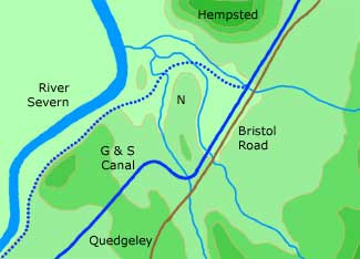
The original surveys
for the canal proposed a route (shown dotted) that avoided the high
ground to the north-west of Quedgeley, but Daniel Lysons of Hempsted
Court objected to this as the canal would have cut through two of
his farmsteads near the river. The promoters were so desperate to
get their plans through Parliament that they reluctantly agreed
to adopt an alternative route (shown solid) which cut through the
high ground.
Alignment of Chosen Route
The
primary consideration was to cut through the high ground at the
point where the ridge narrowed, and this fixed the position and
alignment of the main cutting west of Quedgeley. However, there
was also a need to cross the more modest ridge between the two streams
on which stood Netheridge Farm (marked N). Again it made sense to
cut through this ridge at the easiest point, and there was also
a desire to go around, rather than through, the fields of Netheridge
Farm which extended close to the Bristol Road. These considerations
led to the canal crossing the ridge near to the Bristol Road before
turning at right angles to follow the valley of the Daniels Brook
for a short distance and then turning again to enter the main Quedgeley
cutting.
Easing the Bends
Right
from the start, these two bends so close together were difficult
for ships to negotiate, even with the help of men with ropes on
the towpath, and they became one of the main constraints on the
size of ship that could use the canal. This became particularly
apparent during the severe competition with neighbouring ports during
the early 1880s, and in 1885 some 3000 tons of hard material was
removed from the lower bend by dredging. The issue arose again after
the Second World War when a major programme of work was carried
out to encourage motor coasters to carry cargoes up to Gloucester.
In 1961, the inside corner of the upper bend was dug out by a dragline,
and the earth was dumped to the north-west of the bend in the valley
of the Daniels Brook, after first providing a culvert for the stream.
At the same time, extra-deep piles were driven in around the outside
of the lower bend so that dredging could be done closer to the bank
and so allow coasters more space to swing their sterns. These improvements
allowed many of the coasters to motor round the two bends without
needing assistance from tugs or ropes from the bank. It is ironic
that the eventual elimination of these bends by the construction
of a new cut in 2006 was driven by the need for a major road scheme
and came too late to help commercial shipping. For details of the
work involved in making the new cut, click here.
Sources
Glos RO Q/RUM
2/2; TNA RAIL 829/1; Glos RO D2460/4/4/1; BW Archives 377/89. |