 Helping
to Save a Substation Helping
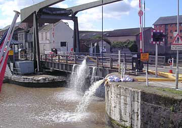
to Save a Substation
One complication
in 2007 that did not arise in 1947 was that the canal was required
to receive water pumped from an electricity substation that was
flooded. The Castlemeads substation across the river from the docks
was put out of action for a time, blacking out parts of Gloucester,
including the docks. The Fire & Rescue Service set up huge pumps
and laid eight 1000 yard long hoses from the substation to Llanthony
Bridge so the water could be discharged into the canal rather than
be put back into the swollen river.
Earlier Problems for the Canal
In both 1947 and 2007, concern about
the river flooding into the canal was preceded by problems due to
excessive water entering the canal from feeder streams. On both
occasions, the flows were so great that even with all available
sluices open, some water did flow over the canal banks, normal traffic
was disrupted for a time and the River Frome burst its banks near
Saul Junction. In 2007, the rise in canal level lifted the pontoons
in the Victoria Dock marina so much that the electricity supply
to the moorings was cut off. The outfall from the Sudbrook culvert
under Bakers Quay caused a potentially dangerous cross flow in the
canal for a time, a bank slip on the off side below Sellars Bridge
brought a small tree into the canal, a nearby slip on the towpath
side made the towpath hazardous and pollution booms were needed
near Parkend Bridge and Sims Bridge.
The
extreme rainfall in July 2007 followed a similar but less extreme
incident a month earlier which caused the cancellation of the annual
Saul Canal Festival (Photos)
Comparison of Floods
In
1947, the peak river level was reached eight days after the canal
level peaked, as much of the river water came from melting snow
far away in the Welsh mountains. In 2007, the corresponding interval
was only three days, as in this case the flood was due to intense
rainfall in the more local catchment area when the river level was
already unusually high following a previous period of heavy rain.
Other reports agree that 2007 river levels above Gloucester were
higher than in 1947, and as the peak level at Gloucester lock was
the same as in 1947, it seems that recent flood relief measures
at Gloucester did give some real benefit.
Sources: Information on 1947 flood from TNA RAIL 864/44. 1947
photos from A Thomas. |